P3: Past, Present, Plan: The LONGER LIST of Diagnostic Questions for low airspace caving
3/22/26 V35 Web version
Main article: https://caves.org/p3-past-present-plan-quick-questions-for-good-decisions-in-low-airspace-caving/
caves.org/stc
Why read this? These questions are worth skimming over because cavers find themselves in unusual environments and situations that cannot be anticipated in advance. A hint of warning recalled can make a big difference. For example, cavers could stumble into dangerous air that wasn’t present before and need to have a sense of the possible hazards to be appropriately alert.
Cavers also travel around to different areas which have different hazards that are not always outlined with neon signs. For example, water release from a nearby dam is not happening on the gypsum plains of New Mexico but it could ruin your day in other parts of the country. On the other hand, the storm drain caves in New Mexico flood completely during thunderstorms: pipe full, game over.
We focus on North America. Other regions of the world to which cavers travel (e.g. cold, hot, desert, tropical) may have additional or different hazards.
Note some of these items can obviously only be done in advance of a trip (e.g. weather forecasts and cave radio setups) and there is some overlap between the time periods.
[1] = this item is mentioned in the first part of the article
[2] = this item is included in the example scenario
Please submit questions, comments, and additional diagnostic questions to stc@caves.org
P1: Past history and events
The Weather as a water source
What is the history of flooding in this cave or area? [1]
What are past trends from the US Drought Monitor (https://droughtmonitor.unl.edu/)? [1]
What is the present situation from the U.S.G.S. Water Dashboard [1] (https://dashboard.waterdata.usgs.gov/app/nwd/en/)?
Do we have local friends and landowners with rain gauges? Due to microclimate, these measurements may be very different from more distant stations.
Can we set up a Personal Weather Station (PWS) on the karst? https://en.wikipedia.org/wiki/Weather_station
What is today’s weather forecast with special attention to the possibility of storms later in the day? [1]
- Research sponsored by IBM claims that their own Weather Channel, weather.com and Wunderground.com have the highest predictive accuracy:
- Accuracy is highly dependent on the geophysical region and data from weather stations which are concentrated around urban areas and may be sparse in karst areas with lower population.
While probabilities are helpful, they may be misleading:
“We knew that no rain was going to fall that night.” How did you know this? Because we had looked at the weather maps, and we knew that a cold front covered the entire eastern US. No clouds anywhere. A local storm cell cannot arise under these conditions. We weren’t relying on a forecast of no rain. We’d seen September cloudbursts (1.5 – 2 inches) on days with 0% official forecasts. So we didn’t rely on that sort of numerical probability computation alone.”—Bill Storage reflecting on the Droughtway, WV
Are climate conditions changing in this area, which may change past averages and introduce new behaviors like extreme downpours? (see, as one example, Taszarek et al., 2021)
The Karst System as a water processing network
Is this area subject to highly localized storms (microcells that may not show up on weather radar)? [1]
What is the size and shape of the drainage basin? (Circular basins may create a sharper rise in water levels whereas elongated basins may have a lower rise but persist for longer periods.) Are there multiple basins that enter the karst system at different points? [1]
Are there parts of the drainage basin that flood especially rapidly? For example, steep gradients in the recharge area, discrete stream sinks, impervious surfaces (urban versus agricultural and forested areas).
What is the condition of the land surface, e.g. drought soil compaction, wildfire damage, waterlogged, frozen or snow?
What is the origin of the sump water, e.g. drip water or flood events or is it an active stream? [1][2]
Is there evidence of recent flooding, for example sediment arrangements, surface debris on the floor or ceiling, etc.? [1]
Does the water level and temperature change over time, for example from surface runoff?
Do we have this data?
Is there water level data available for the basin or nearby basins? The U.S.G.S. maintains a number of gauges that can provide this data and give you an idea of how local basins may respond to rainfall. Instrumentation such as pressure transducers and data loggers (for example, HOBO loggers https://www.onsetcomp.com/) are becoming cheaper and can provide valuable data if installed and maintained. Even simple “staff” gauges or marked ceiling points and tape measures can provide data during trips for sumps that are commonly traversed.
History and characteristics of the sump feature
Can we figure out what conditions have changed and/or did not change? [1]
For example, is this section wet when we expected it to be drier? [1]
Did the sump not dry out as expected (e.g., routine seasonal flooding) or did it unexpectedly get wetter? [1]
Are there comparable features elsewhere in the cave? What are they like? [2]
Who could we talk to about this and similar features? [1]
Are there trip reports or other documentation?
Have caving accidents occurred here? https://caves.org/publications-search/?_collection=american-caving-accidents [1]?
See the June 1984 NSS News on the Precinct 11 rescue to see what can go wrong when entering low airspace caves during unstable weather (Schindel, G., Leitheuser, T., and Veni, G., 1984).
Do we know or anticipate that there are safe shelter areas on the other side of the sump where we could wait out a flood that raises the water level?
Strategically, where are we in the karst system? Are we looking downstream? Are there miles of blank space between this sump and the resurgence, or can we almost see daylight, or is the resurgence spring known to be alluviated, blocked by rubble, etc.? Is this a domestic or livestock water supply? [2]
Or are we looking upstream, with potentially miles of passage on the other side of the sump? Or is there a surface insurgence a short distance away?
Are there hints we are near the surface (insurgence or resurgence) in the form of different temperature air, odors, debris, animal signs, insects, sounds, trash materials, and so forth?
If the feature appears to be short and tight, could we run a video camera through it on a tent pole?
Given all the above, could we use a cave radio to get updates from a surface lookout team if the flood risk is judged high?
P2: Present situation and our team status
The Sump in Context
Is this feature a new discovery or something that has appeared since the last trip? [2]
Has anybody ever been through it?
Are there any alternative routes, including leads or digs that should be reconsidered in light of this obstacle and its possible hazards? [2]
What is the water temperature? Is it unusually cold, e.g. from snowmelt?
Is there airflow that suggests near-sump conditions that may be traversable?
Is the air safe? Sumps can block airflow. Rotting vegetation emits carbon dioxide that can pool up and displace air. Sulfur-compound gases can be hazardous in high concentrations. Methane is flammable. Some cavers have carried meters to measure oxygen and other gas levels.
A future article will consider bad air and bad water in more detail. Preview by John Lyles:
Certain geologic formations also liberate gaseous carbon dioxide without decaying organic matter. Warm River Cave in Virginia has active thermal springs feeding several cave streams of varying temperatures. The historic hot stream is usually sumped near the upstream terminus. CO2 is outgassing here, and it creates a dangerous gas chamber beyond the low airspace.
Is the water safe? Is it contaminated with sewage, livestock or cropland runoff, dead animals, or hydrocarbons like fuel station leaks?
What is the water depth? (may require reconnaissance)
Do we need flotation? (Chas Yonge liked to carry empty mylar wine bags in wet caves because they fold up to nothing and come in handy for deep water.)
What is the airspace like, observed with our best lighting to try to reduce optical effects? (may require reconnaissance)
The Caving Team
Mentally taking two steps back, what is our situation here and now?
Was this immersion part of the plan or is it a surprise? [1]
Is the excitement of discovery affecting our ability to honestly assess our situation and team status? [1]
Are we being impulsive? [1]
What is the condition of our team, particularly its coldest and least experienced member? [1]
What is the readiness of the team? For example, experience in low airspace, attire and equipment, cold sensitivity, fatigue and hypothermia levels, preparedness for more cold compared to the trip thus far, and overall health and readiness status of each person. [1][2]
Are we wet and/or cold already? [1]
What kind of equipment do we have? This can range from attire to dive lamps to a guideline and much more. [1][2]
Have we got what we need to do the caving safely and effectively? [1]
Do we need to modify our trip plan and/or quickly generate a new plan for coordinated action? [1]
Can we reduce at least some of the risks that result from our actions? [1]
P3: Plan of action
What are our goals, limitations, and options? [1][2]
What are the reasons to do this right now? [1][2]
What are the reasons to come back later? [1][2]
What are we forgetting to remember?
Should the team split up? [1][2]
A typical example is a fast reconnaissance by one caver, who is experienced, equipped, and motivated. This recon can provide vital information to make decisions, while most of the team stays drier and in readiness. On the other hand, having two people in long low airspace can help greatly with navigation (the light behind and in front can act as beacons) and reducing optical illusions inherent in a single light, even when held at arm’s length. There are pros and cons to discuss.
What is the window of opportunity: Is this historically low water in drought conditions or can we come back any time we please? If we wait, will water levels drop in the cave making it easier to traverse and safer? [1][2]
What is the window of risk, e.g. what is the weather forecast and is there diurnal (24 hour cycle) risk like afternoon and evening thunderstorms? (In some areas, even dam water releases can raise river levels and thus cave levels.) [1]
What are the consequences of flooding, e.g. being trapped for a day, for an indeterminate period, or certain death because the passages beyond fill completely? [1]
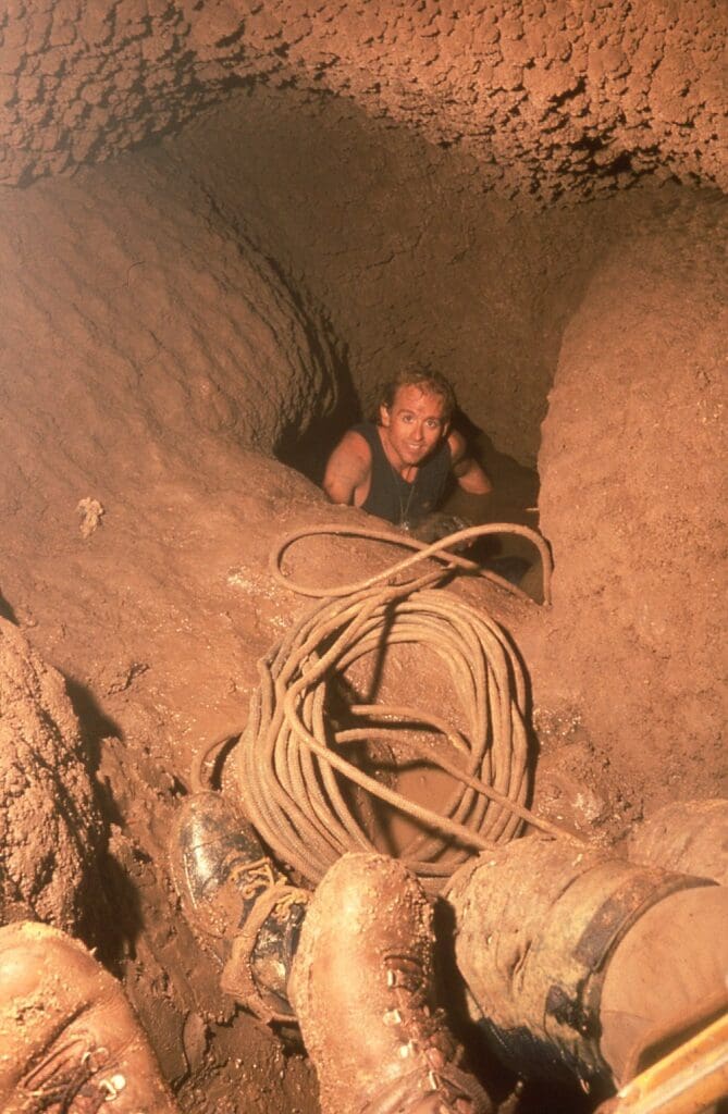
Example of a bathtub chokepoint. Alan Cressler in the “Rebirth Canal” of Pozo de Montemayor, a short tight crawlway that floods completely to form a sump. This feature fills during the rainy season and divides the upper and lower parts of the cave. Alan had been through it when dry and has just done a free dive trailing a rope as guideline. He is assuring us the water is fine! (John Ganter photo)
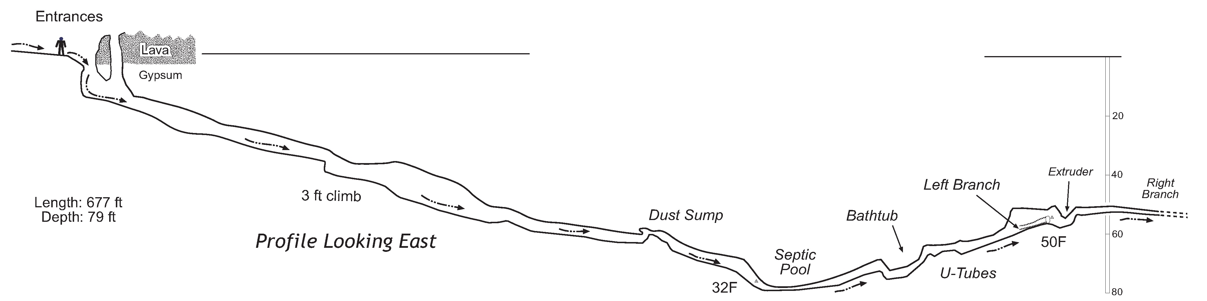
Example of dry chokepoints passed during the exploration and survey trip. This New Mexico cave has multiple dry sumps including a low point (the “Septic Pool”). We saw evidence from debris that the whole cave floods if there is sufficient runoff. It is fed by a couple hundred acres of desert rangeland. (NSS News, February 2001)
What signals from the surface are we monitoring? Typically, these are changes in airflow, water flow, and water level. [1]
Can we lower the water level from the upstream side by diverting, damming, or pumping (typically uphill)?
Can we lower the water level from the downstream side, e.g. one or more cavers go through then move sediment, modify the passage, or set up a siphon or pump?
We thank the technical reviewers for their many suggestions: Jennifer Arbeiter, Hunter Campbell, Jennifer Dougherty, Yvonne Droms, Dave Hughes, John Lyles, Laurie MacDougall, Mark Minton, Bill Steele, and Tim White. The opinions expressed are those of the authors.
References and Resource
(Neven Kresic & Zoran Stevanovic, 2009; Schindel, G., Eady-Pumplin, M, Hudson, S, 2015; Weight & Sonderegger, 2001)
Neven Kresic & Zoran Stevanovic. (2009). Groundwater Hydrology of Springs: Engineering, Theory, Management, and Sustainability. https://shop.elsevier.com/books/groundwater-hydrology-of-springs/kresic/978-1-85617-502-9
Schindel, G., Eady-Pumplin, M., & Hudson, S. (2015). Manual of U.S. Cave Rescue Techniques, 3rd Edition, Version 2.0. Chapter 15: Water Problems.
Schindel, G., Leitheuser, T., & Veni, G. (1984). Precinct 11 Cave: Case History of a Successful Rescue. NSS News, June. www.caves.org
Taszarek, M., Allen, J. T., Brooks, H. E., Pilguj, N., & Czernecki, B. (2021). Differing Trends in United States and European Severe Thunderstorm Environments in a Warming Climate. Bulletin of the American Meteorological Society, 102(2), E296–E322. https://doi.org/10.1175/BAMS-D-20-0004.1
Weight, W. D., & Sonderegger, J. L. (2001). Manual of Applied Field Hydrogeology. McGraw-Hill.
Main article: https://caves.org/p3-past-present-plan-quick-questions-for-good-decisions-in-low-airspace-caving/
3/14/25 V22 added bad air and bad water, weather stations, etc.
4/9/25 V31 Changed to symbols for 1 and 2, added Droughtway interview
8/1/25 V32 Web version: Changed to [1][2] because symbols will not work on the web
8/22/25 V34 Web version: added photo and profile map
3/22/26 V35 Web version: added banner, styled links
